
What Is a Tri-Junction (Trisimana) in Land Survey? Meaning, Example & Identification Process
Two villages in Bihar had argued for years over a small patch of ground where a dry canal met a footpath. Village A said the canal was theirs. Village B said the path was theirs. Then a young survey assistant stood at that exact spot, pointed to a faded mark on the map, and said, “This is the tri-junction. Three village boundaries meet right here.”
The argument did not end in a minute. But for the first time, everyone was looking at the same point.
That one point is what this blog is about. If you have heard the word trisimana during the land survey and wondered what it means, this guide explains tri-junction in land survey in simple words: the meaning, a real-life example, how a tri-junction is identified, and why it matters for your land. You can also use biharbhumiseva.in to read more about survey guidelines and find verified amins.
त्रिसीमाना (Tri-Junction) क्या होता है? Meaning in Simple Words
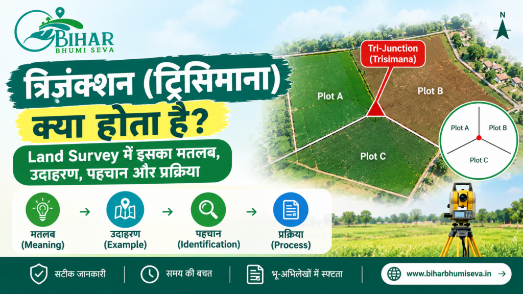
A tri-junction is the point where the boundaries of three villages (mauzas) meet. In Hindi, it is called त्रिसीमाना or त्रिसीमा. “Tri” means three, and “seema” means boundary.
Think of three fields lying side by side, with one corner where all three touch. That single corner is the tri-junction.
| Term | Meaning |
| त्रिसीमाना / Trisimana | Point where three village boundaries meet |
| Tri-junction | English name for the same point |
| मौजा / Mauza | Revenue village |
| ग्राम सीमा | Village boundary line |
| फिक्स पॉइंट | Marker fixed on the ground for the survey |
In the land survey, a tri-junction acts like an anchor. Once the three-village meeting point is fixed, the boundary lines coming out of it can be drawn correctly.
Land Survey में Tri-Junction क्यों जरूरी है? Why It Matters
A tri-junction may look like a small technical detail. It is not. Here is why surveyors care about it so much:
- It fixes village boundaries: Each village needs a clear line between it and every neighbour, and the tri-junction is where those lines connect
- It reduces boundary disputes: When the meeting point is agreed, fewer arguments are left about the lines
- It supports accurate maps: The coordinates of the tri-junction are recorded and used to draw the village map
- It helps plot identification: Plots near the border get placed in the right village
- It protects your record: A plot placed in the wrong village can end up with wrong khata and khesra details
If your land lies near a village border, the tri-junction decides a lot about how your plot appears in the final survey record.
Tri-Junction का Example – A Simple Real-Life Style Case
Let us say three villages, Rampur, Shivpur and Kishanpur, share a corner near an old pond.
- Rampur lies to the north
- Shivpur lies to the east
- Kishanpur lies to the south-west
The pond bank is where all three borders touch. Before the survey, villagers say three different things about where Rampur ends. During the special survey, the team and the officials from all three villages meet at the pond bank. They agree on the tri-junction point, mark it, record its distance from known landmarks, and note its coordinates.
From that one agreed point, they draw the Rampur–Shivpur line, the Shivpur–Kishanpur line, and the Kishanpur–Rampur line. A farmer whose field sits near that corner now knows which village his khesra belongs to.
This is a simple example. In real life, rivers, roads, and old field bunds can make the identification harder, and that is where careful survey work matters.
Tri-Junction की पहचान कैसे होती है? Identification Process Step by Step
According to the Bihar Revenue and Land Reforms Department’s FAQ on special survey and settlement, tri-junction identification is a required step along with correcting village boundaries. Here is how the process generally works.
Step 1 — Prepare the village map
Before fieldwork, the survey team prepares the village map and checks that village boundaries and survey points are complete.
Step 2 — Collect village officials from all sides
Officials from each neighbouring village are called so that all three villages are present at the point.
Step 3 — Find the meeting point on the ground
The team locates the spot where the three village boundaries meet, using the map and old records.
Step 4 — Mark the point
The point is marked with the village names and khata details. Distances from the tri-junction to nearby fixed objects are measured.
Step 5 — Record the coordinates
Surveyors use DGPS to record the coordinates of the point accurately. The department notes that fixed points are observed with DGPS for about 45 minutes and added to the control point network.
Step 6 — Show it on the map
The tri-junction is drawn on the map, and the boundary lines are drawn from it.
Step 7 — Settle objections
If anyone objects, the matter goes through the hearing and objection process. Disputed boundary plots are handled there.
| Step | What happens | Who is involved |
| 1 | Map and village boundary check | Survey team |
| 2 | Call officials of all three villages | Survey team, village representatives |
| 3 | Find the meeting point | Survey staff |
| 4 | Mark the point with details and measure distances | Survey staff |
| 5 | Record coordinates by DGPS | Technical team |
| 6 | Show on the map | Survey office |
| 7 | Hear objections | Settlement officers |
Fix Point और Tri-Junction में फर्क – Know the Difference
Many people mix these two terms, so here is a quick comparison.
| Point | Tri-Junction (त्रिसीमाना) | Fix Point (फिक्स पॉइंट) |
| Meaning | Where three village boundaries meet | A marker placed on the boundary for survey control |
| Where | At the three-village meeting corner | Along the boundary, including tri-junctions and spots where three or four plots meet |
| Purpose | Anchor the village boundary lines | Support accurate measurement |
| Coordinates | Recorded | Recorded through DGPS |
A tri-junction is one type of location where a fix point is placed. So you can think of a tri-junction as the “where”, and the fix point as the “marker”.
Tri-Junction Dispute क्यों होते हैं? Common Problems
Even with modern tools, trouble can arise.
- River change: A river that has shifted its course can wipe out old boundary signs
- Old records differ: Two villages may have different old maps
- Encroachment: Someone may have moved a field bund over the years
- Unclear landmarks: A tree or pond that marked the point may be gone
- Poor communication: Officials of one village may not be present
When the boundary has changed because of river movement or other causes, the department’s guidance says such cases go to higher officials for a decision. That is why it is important to attend the survey camp and speak up in time.
अपनी जमीन के पास Tri-Junction कैसे चेक करें?
You do not have to wait for the survey team to understand where your plot stands. A few simple steps help.
- Look at the village map: Use the online map view to see your khesra and the village border. Our guide to viewing the online map is on biharbhumiseva.in
- Match your khatiyan: Check that your khata and khesra numbers match the map
- Ask for the survey notice: The survey schedule is shared through village meetings and the Circle Office
- Visit the border point with villagers: Go along with elders who know the old landmarks
- Hire a verified amin if needed: An amin can measure and mark the spot, and biharbhumiseva.in lists verified land amin officers for survey measurement and verification
Remember that the online map is for reference and not a legal document. The final record is prepared by the survey and settlement officers.
जमीन खरीदने से पहले Border Plot में क्या देखें?
If you plan to buy a plot near a village border, ask a few extra questions before paying anything.
- Is the plot clearly inside one village, or does it touch the border?
- Does the khesra number on the map match the khatiyan and the seller’s deed?
- Has the survey in that village finished, or is it still going on?
- Is there any boundary objection pending?
A border plot with a settled boundary is usually safe. One with an open argument can become expensive later. Take the map, the khatiyan, and a verified amin with you before you decide.
Bihar Bhumi Seva Tri-Junction के मामलों में कैसे मदद करता है
Bihar Bhumi Seva does not conduct the survey. It is a private help centre, not a government website. Still, it can make your preparation easier.
| Need | Where Bihar Bhumi Seva helps |
| Understand survey rules | Land Survey guidelines page |
| Find a measurement expert | Verified land amin officers list |
| See your plot on the map | Online map and map download guide |
| Prepare survey forms | Prapatra forms and application support |
| Questions | Call +91-7765812226 |
If your land is near a village border, a quick call before the survey camp can help you gather the right papers.
Tri-Junction से जुड़ी आम गलतियां – Mistakes to Avoid
| Mistake | What to do instead |
| Skipping the survey camp | Attend, or send a representative |
| Assuming the village border without checking | Compare map, khatiyan and ground position |
| Ignoring a boundary notice | Respond in time with your documents |
| Not noting old landmarks | Take photos of ponds, bunds, trees and paths |
| Moving or damaging boundary markers | Never touch the markers, as it can lead to disputes |
| Not recording your objection in writing | File it through the hearing process |
Related Blogs:
- Bihar Land Record: Download Your Khatian Online (खतियान डाउनलोड करें)
- Circle Officer in Bihar Roles and Responsibilities Explained
- What are Khata Number, Khasra Number, and Plot Number? Full Details
- Bihar Bhumi Naksha Download – Step-by-Step Guide
- 5 Easy & Reliable Ways to Find the Real Land Owner in Bihar
- How to Apply for Land Registry in Bihar – Process Explained
- Common Land Mutation Mistakes in Bihar & How to Avoid Them
- Circle Officer In Bihar – सर्किल ऑफिसर की पूरी जानकारी, District-wise List & Contact 2026
Frequently Asked Questions – Tri-Junction in Land Survey
Tri-junction क्या है?
A tri-junction is the point where the boundaries of three villages meet. In Hindi, it is called त्रिसीमाना.
Trisimana का मतलब क्या है?
Trisimana means a three-boundary point. It is the meeting corner of three mauzas.
Tri-junction की पहचान कौन करता है?
The survey team identifies it with officials from the neighbouring villages, records its coordinates, and shows it on the map.
क्या tri-junction से मेरी जमीन पर फर्क पड़ता है?
Yes, if your plot is near a village border. It affects which village your plot belongs to and how its boundary is drawn.
Tri-junction विवाद हो तो क्या करें?
Raise your objection during the survey hearing with your documents. Cases involving river changes may go to higher officials.
क्या Bihar Bhumi Seva tri-junction तय करता है?
No. It is a private help centre. Final decisions are taken only by the Bihar government survey and settlement officers.
Final Word
Back in those two villages, the dry canal and the footpath did not change. What changed was that three groups of people agreed on one point. Once the tri-junction was marked and recorded, the lines on the map made sense, and the next arguments were calmer.
That is the simple purpose of the trisimana in a land survey. It is a small point on the ground that keeps three villages, and hundreds of plots, from drifting apart on paper.
If your land sits near a border, check your map, match your khatiyan, and attend the survey camp. For guidance and verified amin contacts, visit biharbhumiseva.in or call +91-7765812226, and always confirm final details with the official survey office.